How some Farmers are turning to Drones, Aerial Imaging for help with Drip System Maintenance
Farmers are investing in drip irrigation equipment, especially subsurface drip irrigation (SDI), to increase yields, reduce inputs and increase overall farm profitability. But drip system maintenance often gets overlooked, partly because the drip irrigation system is underground and can’t be seen.
Drip system maintenance lengthens drip life and improves farm profitability.
-Don Anthony, Anthony Land Company, Lexington, NE

Investing in your investment
Don Anthony of Lexington, NE believes drip systems need maintenance precisely because they can’t be seen. “If a pivot falls over, I know what to do. But since drip can’t be seen, it must be put on a maintenance schedule.”
In Anthony’s experience, ongoing drip system maintenance helps lengthen the life of the drip tape and improves its performance – and helps maximize farm profitability.
New Ag tech gives farmers more options for ongoing drip system maintenance
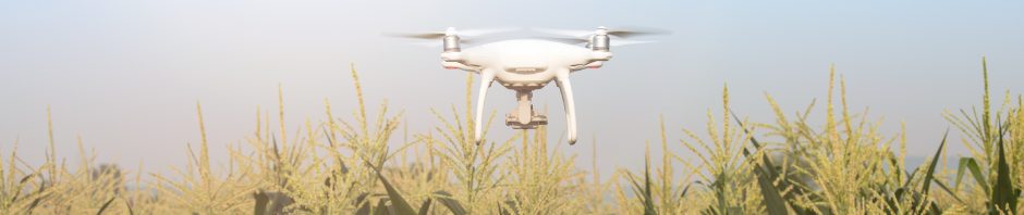
Maintenance practices are evolving as quickly as irrigation technology itself. In the past, lines were flushed with N-phuric acid and visual scouting was used to identify hotspots. Today, fixed wing aircraft, satellites, and drones with high tech cameras are used to scout large acreages quickly and efficiently to reveal problems in real time via color coded NDVI (normalized digital vegetative index) and thermal ADVI (adjusted digital vegetative index) images. The results are nothing short of spectacular.
Aerial images as an early alert system
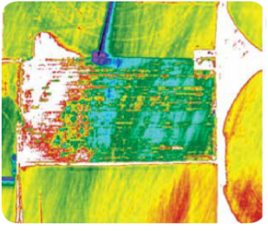
On July 31, 2014 aerial images (Figure 1) revealed white coloration on about 15 acres of Anthony’s soybeans at the end of a rectangular 80 acre drip irrigated block.
In a thermal ADVI image, white indicates crop stress, while green indicates normal crop health.
Armed with GPS coordinates and his tablet device, Anthony and his staff walked through the area indicated in white to troubleshoot, but were unable to visually see a problem.
So they started digging. Once they reached the buried driplines, it became evident that they were clogged and not emitting water.
Later they discovered the clogging was a result of new bacteria that were recently detected in well water samples.
Anthony’s team immediately implemented their remediation protocol.
First, they pressurized the 80 acre drip block. Then they injected chemicals into the system that would lower the pH to 2.0 at the injection point and clean the lines.
Next, they went to the bottom end of the field, opened the flush lines to accelerate the chemical movement to the end of the block, and repeatedly measured the flush water pH with litmus paper.
Once the pH reached 2 in the flush water, they closed the flush valves, went back to the pump station and turned the system off.
They then allowed the chemical to stay in the unpressurized lines overnight before re-pressurizing the system the next morning. The lines were flushed for 30 to 60 minutes before irrigation resumed.
The result?
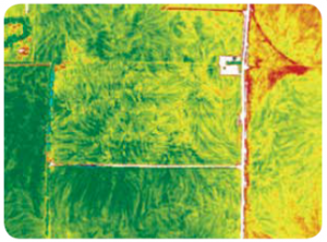
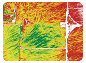
On August 12th, aerial images (Figure 2) showed that the previously stressed area in white had turned mostly green, and by August 14th (Figure 3) the area was completely green, indicating normal, hydrated crop growth.
Problem Solved.
In some cases, drones are used to gather more data after problems are identified with fixed wing aircraft.
Satellite images are also an option, but Anthony finds that it takes too long before results are received.
And if its cloudy? “No dice.” Plus, fixed wing images do not need to be stitched together, like drone images.
Are aerial images worth the cost?
When you do the math, the answer is a resounding YES!
“I spend $10-$12/acre per year on drip system maintenance, and about another $8/ac per year on fixed-wing, aerial imagery for both irrigation and agronomic help,” Anthony says.
“That’s a total of about $20/acre. In this case, if I had not engaged in these activities, it would have cost me 15 acres of $15/bushel beans. Considering that irrigation increases my average yield by 30-40 bushels per acre, in that block alone I would have lost as much as $9,000, or $600/acre.
Spend $20/acre or lose $600/acre? It’s an easy decision.”

Anthony has systematically converted his flood acres to drip since 2006, and today has 320 acres under drip irrigation. All but 12 acres uses Toro Aqua-Traxx® drip tape. “I’ve had no problems with Aqua-Traxx – that’s why I keep using it. If it clogs, Aqua-Traxx can be recovered,” Anthony says. “I’ve also had excellent service from the Toro reps and dealers in the area.”
He notes that drip has a big advantage under low humidity, high wind conditions such as those that occurred in 2012. Dry spring weather can lead to issues with germination, but low-till has helped solve that problem. “Thankfully, the line maintenance chemicals help deter gophers, squirrels and badgers from chewing on the lines.”
Irrigation scheduling technology, such as moisture meters and anometers (evaporation meters), help Anthony fine-tune his checkbook method of irrigation scheduling. This entails replacing what the crop has used on a daily or weekly basis, minus rainfall.
“Properly scheduled drip irrigation helps me save on the first and last irrigations – that’s where the opportunity for savings exists.”
Drip has also helped Anthony prescription feed water and fertilizer according to soil texture variability within fields. “We lay out the drip zones so that different textures are managed differently. For example, heavier clay soils hold more water and are irrigated less frequently than lighter, sandy soils.”
There’s really not much to it–I’ve had good support. Drip has helped me succeed.
–Don Anthony, Anthony Land Company, Lexington, NE
View and/or Download the Drip System Maintenance and Aerial Imaging article here